Create and interpret grid reference systems using grid references and directions to locate and describe positions and pathways
Grid references identify positions consistently. A system must define how letters, numbers or coordinates are read, and pathway instructions must use a fixed orientation…
Ready to project and teach
Learning goalsSay it simply
Grid references identify positions consistently. A system must define how letters, numbers or coordinates are read, and pathway instructions must use a fixed orientation and clear sequence.
AC9M4SP02 - Create and interpret grid reference systems using grid references and directions to locate and describe positions and pathways
Example 1
N 2 E 3 S 1 W 2 endpoint?
Example 2
1. Landmark grid Create a 6 × 6 map with a key and at least eight landmarks, then write references for each. A B C D E 5 Tree 4 3 Pond 2 Cafe 1 Hall
Example 3
2. Route exchange Write a route using compass directions and cell counts; a partner follows it and reports the endpoint. N 2 E 3 S 1 W 2 endpoint?
Example 4
3. Convention comparison Compare cell references such as B3 with point coordinates and explain why the systems cannot be mixed casually. System What is located B3 cell an area/square (2,3) coordinate a point under a defined convention
Curriculum examplesCopied content
The content description and elaborations below show the curriculum ideas taught in this unit. Items marked as teaching context support lesson planning.
Content description: create and interpret grid reference systems using grid references and directions to locate and describe positions and pathways
E1: interpreting a grid reference map of a familiar location of interest, such as a map of the showgrounds, a food festival, a botanical garden, a park in the local area or a train station, and writing instructions using grid references for a friend to find them at a specified location
E2: recognising that a spreadsheet uses a grid reference system, locating and entering data in cells and using a spreadsheet to record data collected through observations or experiments
E3: comparing and contrasting, describing and locating landmarks, people or things in a bird’s eye picture of a busy scene, such as people in a park, initially without a transparent grid reference system overlaid on the picture, and then with the grid overlaid; noticing how the grid helps to pinpoint things quickly and easily
E4: using different sized grids as a tool to enlarge an image or artwork
E5: simulating the actions of autonomous or robotic vehicles moving to different positions within a grid, using grid references and directional language to describe positions and pathways; for example, imitating an autonomous mobile warehouse robot moving stock to different aisles, using grid reference systems to locate positions
Questions and answersWith answers
Core idea: Grid references identify positions consistently. A system must define how letters, numbers or coordinates are read, and pathway instructions must use a fixed orientation and clear sequence.
Remember
Read grid references
Create reference systems
Use compass directions
Describe pathways
Check conventions/endpoints
Important questions
Locate C4 on a grid. Explain using the model or evidence above.
Follow E2, west 2, north 1. Explain using the model or evidence above.
Explain column-then-row. Explain using the model or evidence above.
Why must orientation stay fixed? Explain using the model or evidence above.
Compare a cell and coordinate point. Explain using the model or evidence above.
Practice and reviewReady for practice
Row and column order switched — State and follow the convention, usually column then row for letter–number cells.
North changes during route — Grid orientation remains fixed even after turns.
Moves counted by lines instead of cells — Define whether a move crosses cells or grid intervals and apply consistently.
Cell reference and point coordinate mixed — They locate different features unless the system defines otherwise.
Read the topic guide and use the teacher slide for instruction. Students can then use the worksheet for written work, open Practice for supported feedback, or take the Test when they are ready.
Curriculum alignmentStart here
Grid references identify positions consistently. A system must define how letters, numbers or coordinates are read, and pathway instructions must use a fixed orientation and clear sequence.
After trying the sample, honest feedback is welcome. A TPT review is optional, where available, and does not need to be positive.
Complete learning sequence and evidence
E1: Read a map and describe a route
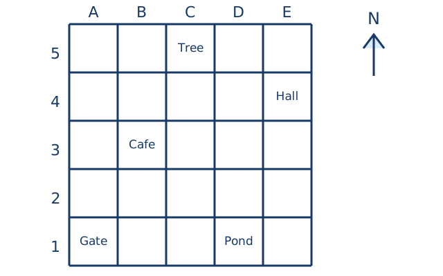
Use the park model below: letters A–E run left to right, row numbers 1–5 increase upward and north is up. Gate A1 to Cafe B3 is one cell east and two north. Cafe B3 to Tree C5 is one east and two north. State a start, the ordered movements and a finish reference. Grid references identify cells; if two objects share a cell, add a within-cell description. A turn changes facing but does not move the traveller.
E2: Enter observed data in spreadsheet cells
Spreadsheet row numbers normally increase downward. Enter Object in A1 and Count in B1. Observe three object types and enter their names in A2–A4 and matching counts in B2–B4. Save a screenshot and read back each cell reference. Moving up from B3 reaches B2 here, whereas north on our park map increases the row number. Inspect the actual cell entries and headings, not merely a paper plan.
E3: Compare a scene before and after a grid overlay
Draw a bird’s-eye scene with two benches and a tree. Ask a partner to locate a bench from an ungridded description. Add a transparent labelled grid and repeat using its cell reference plus a within-cell description if needed. Record which wording was clearer and why. The grid supplies shared labels without changing the objects; it does not guarantee one object per cell or an exact distance.
E4: Enlarge cell by cell
Draw a small picture on a 3 by 3 grid of 1 cm squares. Copy it to corresponding cells in a 3 by 3 grid of 2 cm squares. The new drawing is twice as wide and twice as high. A point halfway along an edge stays halfway along the matching edge. Mark corresponding points to check proportion. Enlarging width alone stretches and distorts the picture; do not introduce coordinate-plane algebra as the target.
E5: Program and debug a route
On the park grid, a robot at B3 facing east moves three cells forward to E3, turns left to north, then moves one forward to E4. Record B3,C3,D3,E3,E4 and the turn. Act this out with a token before running a toy robot. If C3 is blocked, north one,east three keeps clear and finishes E4. Check every visited cell rather than only the finish. Ask why a left turn from south faces east, not west.
Use this model to identify components, positions or matching parts and explain your check.
Year-level boundary
Must teach creating and reading labelled cells, directions and pathways, spreadsheet entry, overlay comparison, grid enlargement and route simulation. Prerequisites are row/column language and simple turns. Distinguish map rows from spreadsheet rows; do not replace cell references with Cartesian-coordinate algebra, bearings or formal scale-factor notation.
Support / Core / Extend
Support: locate one named cell using a finger along the column and row. Core: trace and write a two-stage route and enter observed data in cells. Extend: debug a route around a blocked cell and compare two legal paths.
Exit ticket and adult checks
Make a labelled map, locate two landmarks and act out a route with a turn. Enter three observations in specified spreadsheet cells and enlarge a small picture cell by cell.
Expected evidence and reteaching: Inspect actual map, movement record, spreadsheet and paired drawings. Reteach column-before-row, row direction or equal relative position in enlarged cells according to the observed mistake.
Important questions, answers and assessment review
What does B3 identify in the park grid?
The cell in column B,row3. It contains the cafe; it is a region, not an exact point.
Does turning west move the traveller?
No. Add a movement and a number of cells after the turn to change position.
Why does up from B3 become B2 in a spreadsheet?
Its row numbers increase downward. Check each grid’s labels before following directions.
Assessment: enlarge a 3 by 3 picture from 1 cm cells to 2 cm cells. What changes?
Both width and height double; the arrangement and relative positions in matching cells remain. Review both dimensions if the image is stretched.